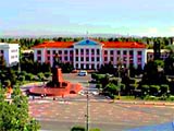
Zhambyl District
Kazakhstan Districts
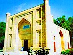
The most interesting and unique architectural monuments of the 11th and 12th centuries in the territory of Zhambyl District are the mausoleums of Babaji-khatun and Aisha-bibi (10th-11th and 11th-12th c.); Zhoshi-khan and Akasha-khan (near Zhezkazgan) dating back to the 13th century; Zhuban-ana, Kaip-ata and Mulim-berdy in the valleys of rivers Sarysu and Kengir; and the Karakhan Mausoleum in Taraz. Taraz played an important trade role on the Great Silk Road, which crossed the valleys of rivers Chu, Talas and Asa. Medieval Taraz was a crowded town with shady gardens and noisy bazaars, where you could hear the Persian, Sogdian, Turkic, Chinese and Russian languages.
Zhambyl district is rumored to be the place where Kazakhstan's "Loch-Ness Monster" lives - the "Aidakhar water ghost" of Kokkol lake. Numerous "witnesses" describe this strange creature as a gigantic snake over 15 m long, with a one-meter wide head.
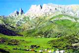
 It is difficult to find a place elsewhere in the world where within a radius of 10-15 km you can see a scorching forested desert and the splendor of mountain ranges with babbling streamy springs. This is Zhusan-Dala, the southeastern part of Betpak-Dala, the largest desert in Kazakhstan.
The Khan-tau mountains are deeply wedged in Zhusan-Dala. Vast plains and flat mountain plateaus located between the towering peaks accommodate small villages of shepherds. Kind hosts are always happy to welcome guests and treat them to strong and refreshing kumys (mare's milk) and incedibly tasty baursak.
The Karatau range is the northwest spur of the Tien Shan in South Kazakhstan. It stretches to the Talas Alatau and gradually dissipates into the Sarysu-Chu plain. Its length is 420km. It is divided into the Eastern or Malyi Karatau and Southwestern Karatau. The highest peak is Bessaz (2176m). The Eastern Karatau has a weakly winding and peaked surface. The Southwest Karatau is sliced by valleys and divided into several massifs. The valley of the Syrdariya river is to the southwest of Karatau, and the Talas river is to the northeast. Karatau has a big influence on the weather and climate conditions of the neighboring areas. Average temperature in January is -10'C.
The difference between average January temperatures on the northeast and southwest mountainsides of Karatau is 4-6'C, because of the influence of a warm mass of air from the southwestern mountainsides. Average annual atmospheric precipitation in the foothills is 200-400mm. The quantity of atmospheric precipitation on the southwest mountainsides is 150-300mm more than on the northeast. The flora is mountainous-steppe. Steppe mice, gopher, steppe polecat, badger, fox and others dwell here.
The Merke river flows through the territory of the Merke district of Dzhambul province and is the right tributary of the Koragaty river. The length is 100km, and the area of the watershed is 645km. It is born on the northern mountainsides of the Kyrgyz Alatau, in the glaciers, and flows into the Koragaty. The valley in the upper parts is narrow and widens near its mouth. Average annual water flow is 3.20m/s. The water is drinkable and used for irrigation. Merke village is located on the banks of the Merke river.
Georgievka village. Since 1930, it has been the administrative center of the Kurdai district of the Dzhambul Province. It is situated 22km northeast of Bishkek, on the right bank of the Chu river. It was founded in 1893. Its population is 22.1 thousand people (1986).