Talgar Mountain Peak
Kazakhstan Mountains Waterfalls and Peaks. Kazakhstan mountain districts
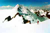
The northwestern slope of Talgar is of trapezoidal form, and large glaciers creep down its southwestern and northeastern slopes, a good panorama of which may be observed from the peak.
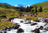
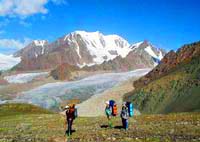
The first ascent of Talgar Peak was achieved in 1935. The ascent usually takes three or four days. There are many attractive peaks nearby, representing both simple and difficult technical routes. The peak is located in the Almaty State Natural Reserve, and special permission is usually required to visit that region. Geographical location. Talgar peak is situated in the Zailiski range of the Northern Tien Shan Mountains. The Northern Tien Shan stretch from west to east approximately 400 km. It is divided into two ranges - the Zailiski Alatau ("the first range behind the Ili river"), and the Kungei Alatau ("bright snowy mountains facing the sun"). The Zailiski Alatau range is 280 km long and up to 60 km wide.
Its northern slopes are in the Southeastern part of Kazakhstan. The Kungei Alatau is situated completely in Kyrgyzstan. This whole mountain system is connected at the Talgar (Chiliko-Keminski) mountain junction, the exact spot where Talgar peak is situated (5017m). The largest glaciers are situated here:
|
|
|
|
|
|
|
|
|
|
|
|
|
|
|
|
|
|
|
|
|
|
|
|
|
|
|
|
|
|
Climate in the Talgar peak region. The climate of the Northern Tien Shan mountains is extreme continental.
Temperature. The coldest month is January, and the hottest is July. Average temperature in July is +3 ° C, but may reach +17 ° C on a sunny day. At heights of more than 3750m, the average July temperature reaches +6 ° C, even in shaded areas. The warmest month in the region of Talgar peak, above 2500m, is August.
Average monthly temperatures at different elevations the in region of Talgar peak
|
Altitude above sea level |
May |
June |
July |
August |
September |
October |
|
2500 |
+5,4 ° C |
+9,1 ° C |
+10,6 ° C |
+10,5 ° C |
+6,5 ° C |
-1,5 ° C |
|
3036 |
+1,6 ° C |
+4,6 ° C |
+6,8 ° C |
+7,2 ° C |
+2,5 ° C |
-2,3 ° C |
Precipitation. Precipitation in July and August reaches 900 mm. Average date of constant snow cover is October 30. Average date of spring thaw is April 2.
Wind. Winds in the area are not strong. A change of wind direction takes place between 8.00 and 10.00AM, when the wind blows from the valleys up-slope, and between 8.00 and 10.00 PM, when it blows downhill mountains. Normally, winds blow at 1.8-2.3 m/sec. Strong winds are very rare, but may occur in May or November.
Avalanches. March and April are the most common months for avalanches.
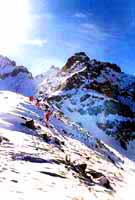
Climbing routes and difficulty. The route we offer doesn't include a visit to the Almatinski nature reserve. Base camp is set up on the "Eden glade" on Gorina glacier - one of the tributaries of the Korzhenevskogo glacier. We leave base camp and head northwest, in the direction of the junction of the side ridge with the Main ridge. We will climb the side ridge, then through an icy gorge. In its lower reaches it is 150m wide. It is also crossed by a large crevasse. We cross over the crevasse on snow bridges, using ropes. Slope is 30 °, rising to 35-40 ° in the upper part of the gorge.
It will be necessary to set up 100 m of ropes, using ice protection (screws). In the upper part of the gorge is an icefall, where the gorge narrows to 10 m. We then ascend from here to the center of the ridge. Attention! There may be unstable snow cornices on the right! Further travel on the ridge is not difficult, but requires attention. The ridge leads to the summit of the Main Talgar peak. As a rule, the snow here is very deep. It takes 3-5 hours (2 - 2.5 km) to get from the ridge to the summit. In sunny weather, rockfalls from the eastern slopes of Talgar peak begin at 10.30 - 11.00 o'clock in the morning and finish at 02 - 03.00 p.m. On the western slopes, they start at 01.00 - 02.00 p.m. and finish by 06.00 p.m.
Climbing history. The first summit of Talgar was performed in 1935 by a group of climbers guided by V. Zimin ("Zailiski Alatau" - V. Stepanova). However, other sources say that Talgar was climbed for the first time in 1938 by a group of climbers from Stalinsk (modern Novokuznetsk).