History of Almaty
Echoes of Past Centuries. Almaty history. The city of Almaty
 The history of the region began long before a military fortress was founded on the Malaya Almatinka River, in the foothills of the Alatau Mountains, in the middle of the 19th century.
As early as the Late Bronze Age, in the 10-9th centuries BC, the area was inhabited by settled tribes who engaged in farming and cattle-breeding. Those people lived in earthen-houses forming small settlements. Such settlements have been discovered on the northern outskirts of the city and in the area of Koktyube Mountain. Later, the Sakian and subsequently the Usun tribes came to settle in the Almaty area. These tribes left behind numerous burial mounds which were discovered only recently in the old town.
In 1969, the ancient Sakian mound Issyk was excavated near Almaty. In the grave, ringed with fir logs, on a wooden floor, were found the remains of a Sakian warrior dressed in clothes covered entirely with golden plates. His high pointed hat was decorated with the images of winged steeds symbolizing the God of the Sun. The warrior's arms were a long sword and a short dagger. Also found in the grave were clay jars, wooden trays, precious jugs made of silver and bronze, and a silver cup, on the bottom of which they found an inscription consisting of 26 mysterious signs. The Issyk burial mound is believed to date from the 5-4th centuries BC. In 1974, the so-called Golden Man was exhibited at the Leipzig Fair where, incidentally, the capital of Soviet Kazakhstan was for the first time widely presented to the European public.
Excavations of the sites of ancient settlements provide evidence of their long history.
 In 1938 the researcher, B.X. Dublitski, excavated an ancient settlement on the territory of the state farm of Gorny Gigant, representing a 140xl50 meter ground protected by a quadrangular clay wall, with four round watch towers erected at the corners. Inside the site, they found numerous fragments of ceramic and clay tableware, an iron knife, long iron nails, beads made of red-and-brown transparent stone, and bones of domestic animals. At a depth of 110 centimeters from the floor, they discovered a stone fireplace, remains of a tandyr, and the mouth of a badrab. Near the fireplace were found fragments of a jar decorated with an imprint of the sun. The settlement dates back to the 10-13th centuries.
Of greatest interest are the remains of an ancient settlement in the area of the Frontier Military College. In 1894, V. V. Bartold, who explored the site at the request of the architect, P.V. Gourde, wrote: "Verny dwellers smashed the baked-brick buildings to pieces for their household needs." In our time, two silver coins have been found at that site during construction operations. Judging by their form, metrology, and coining technique, the finds resembled coins minted by the Central Asian and Eastern Turkistani towns late in the 13th-early in the 14th centuries: "This dirham was coined in the area {balad) of Almatu in the year of five ...". The word was coined without dots but its graphics allowed the scientist V. N. Nastich to read the inscription as "Almatu" and to see in it the name of a settlement that existed on the territory of the present-day Almaty in the 13th century.
Among the random finds connected with the Sakian tribes we should mention bronze lamps, caldrons and sacrificial altars. A broad range of such articles was collected accidentally on the territory of Almaty and in its vicinity. Of interest is a sacrificial altar which is known in literature as "the altar of Semirechye". It is now kept in the Hermitage. It was found before the Russian revolution in the vicinity of Verny. The altar is a tray resting on four short legs. Placed along the edge of the table are 25 figures of winged snow leopards.
 The Vesnovka site was located in the area of the Botanical Garden in Almaty. In 1969, during construction, a number of original ceramic articles were found. Of greatest interest are jars coated with glaze.
It was in the time of the Usuns that one of the most well-known articles was also found near Almaty - the so-called "Kargaly diadem" - which dates from the 2nd century BC.
It may be not out of place to note that the history of the town's science dates back to the 19th and early 20th centuries, thanks to regional pursuits and findings made by N. Abramov and V. Nedzvetski (description of old Almaty), K. Borisoglebski and S. Troparevski (photographic fixation and measurement of historical and cultural monuments), G. Kolpakovski and F. Poyarkov (collection of manuscripts and coins, submarine archaeology research), N. Pantusov and Pozdneyev (a study of petroglyphs and "kairaks" of the days of Buddhism and Christianity in Central Asia).
Based on data contained in written sources, coins and other archeological finds, we can say with confidence that the modern city of Almaty emerged under the name of Almatu as early as in the 10-11th centuries, and the area of Almaty had been inhabited by nomad tribes in the Bronze Age.
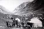
...In mid-summer 1853, a military detachment headed by Major M. D. Peremyshlsky, a police-officer of the Big Horde, left Kopal for the ancient crossroads of Oguz-Utkul, leading across the capricious Asian river Ili to the mountain jailyaus of Turghen and the syrts of the Central and Inner Tien Shan. The major was instructed to conduct diplomatic and economic negotiations with the peoples that lived there seeking to enlist their cooperation in trade and industry and to persuade them, on the whole, to enter into an alliance with Russia.
The negotiations succeeded, and by the next spring a Cossack squadron led by Lieutenant Glakhyrin explored the territories along the Trans-Alatau, constructed a bridge at the junction of the rivers Kurta and Shi, and started erecting a fortress on the banks of the Malaya Almatinka river.
The construction was carried out based on '"The Design for a Fortress beyond the Ili River, on Almaty Tract, which is in the Big Kirghiz Horde" approved by the imperial resolution of March 7, 1854. The general project had been drawn up by Russia's leading builders A. Telyakovski and E. Totleben; the ground plan was done by topographer E. Vorinin, and engineers L. Alexandrovski and Ts. Gumnitski. On the document, emperor Nicolas I penciled his resolution: "I agree, but do not send the exiled to settle there for the time being". The prescript was confirmed by Article 28 260 "On Construction of a Fortress Named Zailiyskoye" which was later renamed Vernoye (Article 29 772 of the Complete Collection of the laws of the Russian Empire, Volume XXX, 1854).
 In 1859, the astronomer and land-surveyor A.F. Golubev, who had been sent from St. Petersburg, determined the coordinates of 17 of the most important geographical locations, including the fortress of Vernoye, and for the first time put them on the map. In the meanwhile, the St. Petersburg Bulletin's correspondent, noting this important event, reported the following to his Russian readers: "Our fortress is growing hour by hour, not day by day. It cannot but flourish in a land which boasts all the gifts of nature and which has waited so long for the establishment of civilization. It was not long ago that there was a desert here which had never seen any settlers since the creation of the world and which was only visited by nomads, and now there is a town here with more than five thousand dwellers! Believe me, in less than ten years our Vernoye will turn into a large town of which not only the Siberian but also the Russian towns will be envious..."
The fortress of Vernoye became a starting point on the routes of the first scientific and practical expeditions. It was here that Chokan Valikhanov studied the way of life, traditions, and tribal relations of the Tien Shan peoples. During the journey around Semirechye as a member of the expedition led by M.M. Khomentovski, head of the Alatau District, Chokan Valikhanov kept a diary illustrating what he saw with pencil drawings and pictures in watercolors.
The talented Siberian painters Mikhail Znamenski and Pavel Kosharov captured the look of the new settlement on their canvases. Three of their pictures are well-known. The stanitsa square is the composition center of their paintings. In the middle of the square is the small wooden Sofia Church consecrated by Senior Priest Yevtikhy Vysheslavski in 1858.
On 11 April 1867, a decision was made to give the fortress of Vernoye the status of a town. This town, Verny, became the center of the Semirechye District of Turkistan Province. They began to establish structures within Turkistan Territory (Stepnoi Territory in 1882-1899): the Regional Board headed by the governor-general: the Turkistan Eparchy with the bishop of Turkistan and Tashkent sojourning in Verny; the Cossack Host Board with election of the ataman of the Semirechye Cossack Host; and other institutions for the development of the land. Issues relating to the municipal economy before the Verny Town Duma was elected had been dealt with by the Town Office of the District Board.
 On 13 November 1877, the election to the Duma took place. Pavel M. Zenkov (1830-1915) was unanimously elected the first mayor of the town of Verny. The town head had been born into a family of Ural serfs. Having no special education, he used to be registered in different agencies either as a free artist or as a free architect. In autumn of 1867, P. M. Zenkov, with his family arrived in the town of Verny, construction of which was under way. He took part in the elaboration and implementation of the first development plan, and exercised supervision and control over construction operations. P. M. Zenkov's multifaceted talents did not only show in architecture, painting, and sculpture, but also in music, literature, science, and the public life of the land.
Verny fortress was arranged and its public and civil buildings were designed by engineers of the Turkistani and West-Siberian military districts, graduates of the Saint-Petersburg Engineering Academy, the Institute for Civil Engineering, and the Communications Institute. Leonard Alexandrovski, Tsezar Gumnitski, Apollon Kamenogradski, Nikolai Krishtanovski, and Pavel Zenkov and his son Andrei were the first . The first town architect was G. N. Serebrennikov (1839-1883), the author of the first cathedral in the name of the Protection of the Blessed Virgin. In 1934, while building the Komintern Square the Protection Cathedral was destroyed together with its courtyard. Today, Amangeldy Imanov Park is situated here.
The second and last architect of the town in the years preceding the Revolution was a Frenchman, Paul Gourde (1846-1914), who invented the first ever coat of arms of Vemy, which was validated 19 March, 1908, and created the first relief map of Simirechye, presented at the World Exhibition in Paris. He pioneered the first archaeological excavations in Almaty and displayed other initiatives in the sphere of culture which resulted in his being awarded the title of the Honorary Town Citizen.
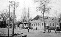
The town merchants were the great philanthropists of the town. There were churches, institutions of worship and schools erected, as well as public services and amenities organized with their money. Verny had 11 mosques, two synagogues, a Roman-Catholic church, and Orthodox churches. Of the latter, only a few are functioning - Turkistan Cathedral, revived on Ascension Day in 1995, and Malostanichny Church in the name of the icon of the Kazan Blessed Virgin, the heavenly protector of Semirechye, which was constructed back in 1871 in memory of the founding of the Cossack stanitsas.
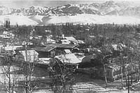
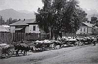
The squat one-storied structures were the result of the local architects' conviction not to erect high stone buildings in an area subject to frequent earthquakes. Seeking to preserve Verny's architectural image, the builders employed traditions of wooden architecture as an echo of the past. Wooden structures were crowned with hipped roofs and decorated with various traditional carvings. Such buildings did beautify the dusty and ill-equipped streets. Forged open-work signboards were fixed on the carved porches: "Trade House of G. A. Shakhvorostov and the S-s", "Successor of Commerce Councilor N. I. Ivanov", the "Europe" hotel, the "Paris" restaurant, fashion houses "Warsaw" and "Vienna" where ladies' hats and shoes were sold, the "XX Century" cinema, Telephone, electricity, automobiles, and running water appeared. The only regional newspaper, "Semirechye Gazette" wrote, not without irony, that "under the conditions of an epidemic disease of seeking to maintain the reputation of a half-amateurish or unsuccessful establishment with the help of a grand sign with a promising name on it we should rather think of renaming Verny into the town of... Rename."
Beginning in 1869, the town began to extend to the southwest of Bolshaya Almatinskaya Stanitsa. The first town blocks of buildings appeared along Tashkentskaya Alley (today's Raiymbek Avenue). The Sennaya Square (nowadays the square in front of the Young People's Theater) became the central square of the town, where the grand Protection Cathedral was constructed. Yet the first construction experience proved unsuccessful and the buildings were unable to withstand the force of nature. On May 28, 1887 the town was completely destroyed by a devastating earthquake.
Eyewitnesses said that the underground elements awoke the sleeping town at 4:35 in the morning. Within five minutes, the shaking reduced to ruins the best 1,799 buildings of the New Town, among which were the governor's mansion, 4 grammar school buildings, the archbishop's house, and the Protection of the Blessed Virgin Cathedral. At that difficult time the town authorities tried to support people with both words and deeds. The badly injured Governor, A.Ya. Fride did not cease providing assistance in supplying bread, clothes, and medicines for citizens. The honorary senior citizen of the town, Seid Akhmed Seidalinov, arranged yurts and hot meals, and provided shelter for those suffering in the neighboring auls. The Right Reverend Neofit held a national service. The burial service was read in a field tent/church for the 332 killed in the earthquake, mainly children who died of severe injuries, after which their bodies were committed to the earth.
 Already , in those distant times, they had started developing scientifically sound regulations for construction in the town situated in a seismological zone. Yet, due to the high costs of the projects, the builders made use neither of recommendations by the scientist I. V. Mushketov nor of the proposal to apply new construction materials and structures when erecting buildings put forward by local architects. After the earthquake of 1887, Verny became a solely wooden, one-storied and squat town.
Another problem of town improvement always lay in the development of the town's layout. The first general plan of 1868, drawn up by N.I. Krishtanovsky and P.M. Zenkov, was approved by the general-governor of Turkistan Territory in 1874 when they had already started building the town. Besides, the area required for estates and pastures was significantly curtailed when approving the plan and came to amount to only 443 square hectares for construction of the town. That is why the town's territory increased at the expense of development of the fortress of Verny (1854-1889). The Bolshaya (1855-1927) and Malaya (1860-1962) Stanitsas, and the Tatarskaya Sloboda (1857-1962) and the town's other suburbs constitute today Medeu District of Almaty.
According to poet Vyacheslav Kiktenko, the city in the past was divided into three unequal parts: below the river, along the river, and beyond the river.
Verny below the river resembled a model village, founded by migrants from various parts of Russia, rather than a town: a sturdy izba, a yard around it enclosed with barns, sheds, cellars, icehouses, bathhouses, stables, awnings for household equipment, and other outdoor buildings. The settlers brought their local methods of construction, and their tastes, customs and religions into the architectural arrangement of the first streets in the "New town". For example, they would pour the blood of a slaughtered rooster upon the load bearing stones of the foundation. They would put corn under the lower rim to become rich, incense to be protected from evil spirits, and wool for warmth. It is interesting to note that peasants would bring to Semirechye the dearest things: wildflowers in tubs from Siberia which would smell sweet on cold days on the windowsills, flat heavy stones carefully wrapped in rags from the Volga River region (the stones were used as a press when making sauerkraut). As to flowers, stones, and sunshine, nobody would have been in need of them in the mountainous Semirechye land. Yet the rural way of life had a negative impact on the town's look and development. The land lots purchased for building houses were actually used for farming and gardening, for building barnyards and inns. A new type of town resident appeared, the town kulak.
 Below the river the town was grouped along one street, originally Sobornaya, then General Kolpakovsky, later Lenin (Ilyich), and now Dostyk Avenue, which connects the city's business center to the Medeu Tract suburbs. In 1875, in place of the unwanted fortress wall , they set up the spacious Gostiny Dvor, which became a covered market one hundred years later. Where sits the Eternal Fire in the City Park toda, a large Orthodox cathedral was constructed which was ruined in a grandiose earthquake three years later. On that very day which is hard to forget, on May 28, 1887, the earthquake also destroyed to their foundations the trade and industrial centers of the Kuznetsovs, Pugasovs, Ivanovs, Lutmanovs, and Ogorodnikovs, situated on the territory of today's Abai Square and Avenue. In memory of those killed by the force of nature a chapel was built in the center of the Gostinodvorskaya Square (it was demolished in 1927).
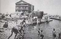
The territory along the river and beyond it was the domain of craftsmen and merchants. Up to forty agricultural and industrial enterprises grew on the banks of the full-flowing and rough Almatinka River (which became quieter after the mudslide of 1921, having found apparently subterranean channels) as well as along its water canals. Working suburbs and dachas appeared around untiring water-mills.
This area beyond the river was divided by today's Abai Avenue into lower and upper garden plots. In 1896 the banks of the mountainous river were connected by a bridge. It was constructed most likely by the engineer Nikolai Naranovich. However, peoples' memories retained it as Pugasov Bridge after the last name of the first guild merchant, the town's benefactor Nikita Pugasov. "The bridge was gracefully bent, the crown of the merchant's notable prosperity, creaking it was, with railings", said the poet about this engineering structure of the past.
It was here, at the mill famous at least for the fact that after the earthquake of 1887 they would feed the citizens of the destroyed town with bread for free, that Nikita Pugasov started his business activities. The merchant lived not far from the crossing. Only a century-old oak tree is left in the place of his estate, a peculiar embodiment of the merchant's well-being. Nothing more. Only the poet's words: "However, it is not simple to burn names and bridges, if we cross again Pugasov Bridge, as before, you and me".
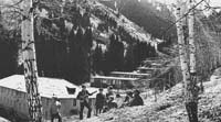 In 1978, The Medeu Tract, the Kamenskoye Plateau, and the territories of the farms Koktyube and Gorny Gigant were included into the city boundaries. The territory of the city increased to 172.38 square kilometers.
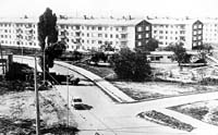
These days, the western and northeastern parts of the city are the areas with the most active growth of the city's territory. There are being built the housing estates of Taugul, Mamyr, Kamenka, Baganashyl, Koktyube, and Gorny Gigant. Construction of the micro-district Samal, where they erect monolithic 9, 12 and 14 story buildings, will soon be completed.
Statistics show that by the beginning of 1998 Almaty had 1061.4 thousand inhabitants: 202.8 thousand in Almaty District, 256.0 in Auezov, 229.7 in Bostandyk, 120.5 in Zhetysu, 137.9 in Medeu, and 114.5 thousand people in Turksib District.
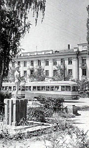
Decades in the life of the city have passed. The Big Stanitsa was destined to become the capital of Soviet Kazakhstan. Later it turned into the "Southern Capital", into a city where the modern history of the sovereign and independent Kazakhstan began. Alma-Ata was drawn into the whirlpool of political, social, and economic events as a result of which both the Union of the Soviet Socialist Republics and the Kazakh Soviet Socialist Republic ceased to exist. On 30 August 1995, the new Constitution was adopted. Almaty became the first free city in Kazakhstan, a special administrative and territorial formation of national importance, the center of the cultural, scientific, financial, economic, and political life of Kazakhstan.
By Karl Baipakov and Vladimir Proskurin